 Airbus Defence and Space
The CURE System
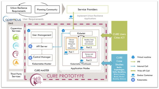
CURE developed a System for urban resilience on WEkEO platform of DIAS (Data and Information Access Services), consisting of 11 individual cross-cutting applications. The CURE data products, linked to the CURE System are open and available for demonstration and evaluation, via the CURE Portal, including web-based exploration and analytical capabilities. Below, you will find the list of the 11 CURE cross-cutting applications including concise information, the purpose of development, the developer organizations and the cities of application.
Local Scale Surface Temperature Dynamics
The surface temperature is one of the most important parameters in the physical processes of urban surface energy, water balance and the land-atmosphere exchanges. Thence, it constitutes a valuable information source for the understanding of the natural and human components of the Earth system. In this context, the anticipated application was utilized in all urban areas involved in the project, leading to frequent local scale surface temperature estimations, which are essential data for other CURE applications too, i.e. the Surface Urban Heat Island (UHI) Assessment application, the Urban Heat Emissions Monitoring application and the Urban Heat Storage Monitoring application.
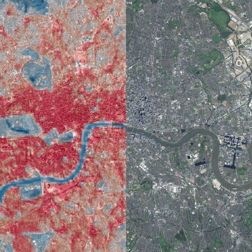
Surface Urban Heat Island assessment
An urban heat island (UHI) occurs, when a city experiences much warmer temperatures than nearby rural areas. Warmer air caused by UHI increases: i) the heat load stress of urban residents, potentially raising the threat of mortality; and ii) energy consumption and associated greenhouse gas emissions due to the use of air conditioning. Hence, properly identifying UHIs can contribute to the effective evaluation of potential heat risk. In this framework, the intended CURE application assesses the UHI intensity for any engaged city through remote sensing data, as well as tracking its trend over time and detecting hotspots. These outputs assist urban planners in understanding how critical the phenomenon is currently, monitoring how it is evolving, and taking suitable decisions accordingly.
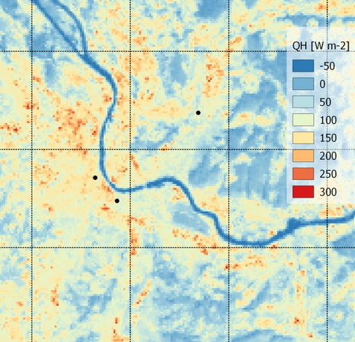
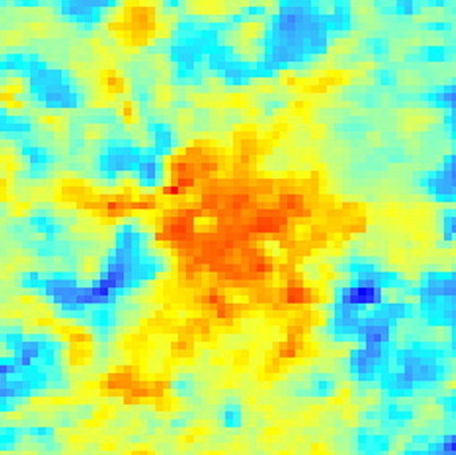
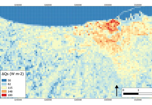
Urban Heat Emissions Monitoring
Urban heat emission refers to the turbulent sensible heat flux, i.e. the heat exchange between the urban surface and the atmosphere. The sensible heat flux defines the amount of energy that is available for heating the urban atmosphere and it is thus closely related to air temperature. This amount of energy is strongly modified by the properties of the surface (land cover/use and 3D geometry) and the input of heat by human-related activities (traffic, housing, industry). The localization of hotspots of high heat emissions will help urban planners to optimize their adaption strategies, considering also heat stress, urban green space and building development. Focusing on CURE, the expected application estimates sensible and latent heat fluxes in urban environments, pinpointing the above-mentioned hotspots.
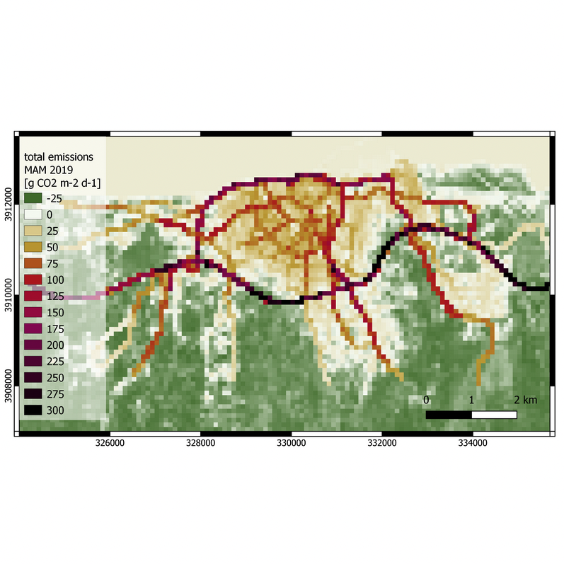
Urban CO2 Emissions Monitoring
The total urban CO2 emissions have spatial dimension due to the heterogeneous nature of urban land use/cover and urbanization in general. In this CURE application, the CO2 emissions are partitioned into an anthropogenic (traffic, heating/cooling) and a biogenic component (urban green space). Spatial planning strategies have an influence on the urban form, and consequently affect CO2 emissions through changes in traffic patterns, energy consumption, and location and extent of urban green areas. Knowing the portion of the anthropogenic and the biogenic part of CO2 emissions in a high spatial resolution (neighborhood scale) provides urban planners with an additional decision support tool for developing emission reduction strategies.
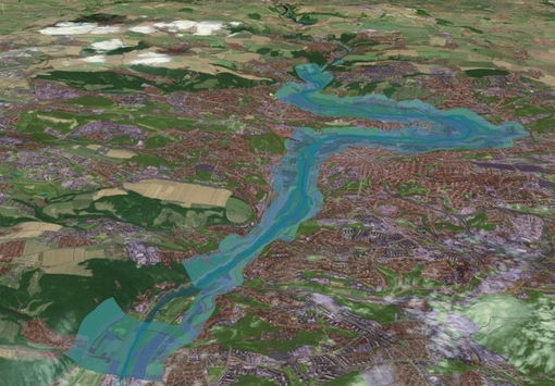
Urban Flood Risk
Floods are the natural hazard with the highest frequency and the widest geographical distribution worldwide. Due to societal assets concentration in cities, floodings can cause major disruptions and lead to significant impacts on people, economy and environment. Thus, potential flood risk has to be taken into consideration seriously, especially under the ongoing climate change, i.e. large increase in the number of extreme natural events, such as storms, cloud bursts or sea surge. CURE proposes a solution, which (i) captures the multi-scale aspect of flood risk assessment providing relevant information and (ii) contributes to rapid flood monitoring. Therefore, this Urban Flood Risk service supports urban planners both during city preparedness and climate adaptation activities, as well as during emergency situations with information support to city response activities.
Urban Subsidence, Movements and Deformation Risk
Ground and construction movements are responsible for hundreds of deaths and billions of Euros lost annually. In a more and more urbanized world, the threats of urban subsidence, slope instability (landslide risk) and building or infrastructure deformations are also deteriorating due to (i) the large increase in the number of extreme events related to climate change and (ii) the sub-optimal building and infrastructure maintenance. CURE proposes a solution based on interferometric persistent scatters (PSI) technique – processing time series of high or very-high resolution satellite radar imagery – to detect up to millimeter displacements. The service is utilized for subsidence risk assessment, coupling hazard monitoring with up-to-date assets information (land cover/use at building block level, buildings or grey infrastructure elements). The provided accurate assessment of threats and identification of vulnerabilities is critical for urban planners to understand and manage the subsidence risk to the actual city assets.
Urban air quality
- Developers: VITO
- Area of Implementation: Sofia, Bristol, Ostrava
Air pollution is one of the main environmental issues in urban areas. According to a recent report of the European Environmental Agency, more than 400.000 deaths in the EU are related to air pollution every year. Urban air quality is a multi-scale issue. Pollutant concentrations at street-level scale are influenced by regional (rural) background concentrations. Urban increments arise from local industrial and traffic sources, and an additional contribution comes from recirculation in street canyons. CURE proposes a solution, which captures the multi-scale aspect by incorporating several models into an integrated model chain. The application provides street-level (5m resolution) maps of nitrogen dioxide concentrations for entire urban areas, which allow stakeholders to identify pollution hotspots in the urban metropolitan region. Additionally, the model chain allows the assessment of pollution reduction measures, such as the introduction of low emission zones or pedestrian streets.
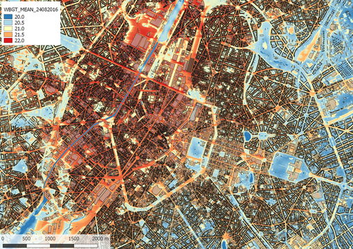
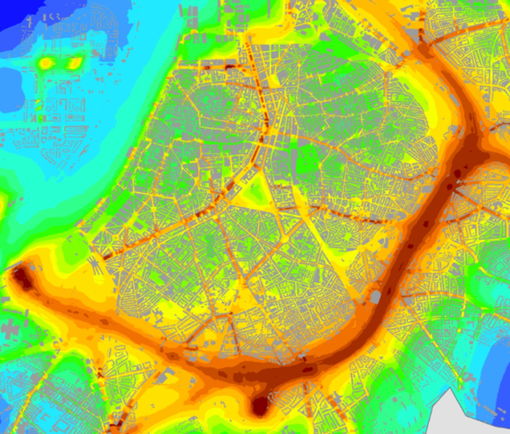
Urban thermal comfort
- Developers: VITO
- Area of Implementation: Copenhagen, Sofia, Ostrava, San Sebastian, Vitoria-Gasteiz
Heat stress is an increasing problem in many European cities, having a negative impact on sleep, productivity, health and mortality of urban residents. Citizens experience higher levels of heat stress than people in rural areas due to higher air temperatures (Urban Heat Island effect), lower wind speeds and higher levels of solar and thermal radiation coming from building materials. This CURE application quantifies and maps human thermal comfort for a typical hot day at a very high resolution (1-2m) for entire urban areas. This allows urban planning and development stakeholders to identify hotspots and give them insight into the local variation of heat stress. Furthermore, the application allows users to upload different land use scenarios and assess the effectiveness of adaptation measures, e.g. green-blue infrastructures.
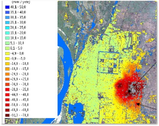
Urban Heat Storage Monitoring
Observations of global temperature evolution indicate a pronounced air temperature warming, since an increase in the occurrence of heat waves and the Urban Heat Island (UHI) effects tends to exacerbate such warming. Among all the effects caused by the substitution of natural ecosystems for urban land-use, the most pronounced is the increase in the amount of energy stored in the urban canopy (especially in buildings), which is approximately 2-6 times larger than in non-urban canopies. The slow release of this energy, stored mainly in the buildings and paved surfaces of cities, causes the UHI effect and it is therefore related to the energy efficiency and consumption in cities. In this framework, the CURE application deploys various earth observation and in-situ urban data, such as land cover, geometry, radiation and air/surface temperature, towards monitoring urban heat storage.
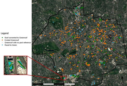
Nature-Based Solutions
Nature-Based Solutions are gaining relevance for the enhancement of urban sustainability and resilience, given the increased evidence about a wide range of multiple socioeconomic, environmental and climate related co-benefits, which they provide. Specifically, green roofs could improve performance of single buildings (e.g. energy consumption), while generating at the same time important positive effects in public spaces at city scale, such as water run-off regulation, contribution to urban heat island moderation and air quality improvement. This application allows urban planners to quantify maximum potential deployment of green roofs by assessing at city scale key enabling conditions for installation (i.e. roof size and slope, orientation, use, shadowing and other building suitability factors). Alongside, in combination with other applications, benefits related to key resilience challenges such as flooding, heat stress or air quality are modelled and evaluated. Both outputs inform local decision making by benchmarking alternative scenarios of green roofs potential.
Health Impacts (Socioeconomic Perspective)
- Developers: CWare
- Area of Implementation: Copenhagen, Sofia, Bristol
The enhancement of human health and the increase of human resilience through improved city planning are key challenges. Substantial health economic benefits can be achieved by creating healthy cities, where air quality remains below critical levels and health promoting aspects (such as walkability, bikeability and access to green areas) are prioritised in urban planning. In general, there is increasing evidence that these aspects have a positive effect on the disease profile of cities, e.g. the incident of obese, diabetes, respiratory diseases and cancer. For instance, once a person is diagnosed with diabetes mellitus, the health costs increases twofold compared to a person without diabetes, equal to an additional cost of 15.000 € per year per patient. CURE supports the above prioritisations through its specific cross-cutting Health Impacts application, which uses health data (e.g. mortality, illness, demographic data) and links them with city living conditions.